Aug 28, 2015

(Ensemble) Hydrological Modelling, calibration, and FUSE

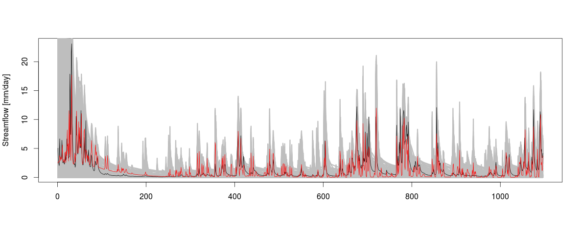
Claudia Vitolo has a series of R tutorials for using a single hydrological model, or a combination of models to estimate hydrological component using a modular framework to diagnose differences between hydrological models.  I find it very interesting, and seems the procedure can be integrated to be used in our approach of estimating large scale hydrological components using JGrass-NewAGE system. That mean while the FUSE can be used to estimate the any component at the subbasin scale and use to estimate the uncertainty in the prediction,  while the  JGrass-NewAGE system can be used to integrate the process to estimate at large scale. This is in my list to try in near future! 

The three tutorial are:
  1.  FUSE model in RHydro package (part 1: simple simulation) Here
  2. FUSE model in RHydro package (part 2: calibration) Here
  3. FUSE model in RHydro package (part 3: ensemble) Here

Enjoy it ! 

Aug 26, 2015

Water stress country ranking

The WRI published a report on  the level of water extraction in relation to the available surface water, and able to come up with water stress  ranking of all countries. Water use in different sector such as domestic consumption, agricultural farms, and industrial sectors will be influenced by the change in the water availability, and will have direct impact on economic development.   Anyway, the 10 most stressed countries are  Bahrain, Kuwait, Palestine, Qatar, United Arab Emirates, Israel, Saudi Arabia, Oman and  Lebanon. The whole report can be read at here
This map shows  spatial distribution of the  projected  water stress by 2040: some of the high projected stress countries are middle east countries, India, China, South Africa, Botswana, Australia, Morocco and Tunisia, Libya, USA, etc

Aug 18, 2015

Drought in Ethiopia

According to different sources such as relief web , news24, and European commission for humanitarianism aid,  in this year, there has been a drought in Ethiopia, particularly in the Easter and Southeastern part of the  country.  I have been closely following the news in this regards, and some of the News  shows the level of severity on human is  really shocking. I am  deeply sadden.  For a glimpse view  on the nature of the drought is documented by this aljazeera video.  According to the European commission for humanitarianism aid  Easter Tigray, Wollo, Shewa, Arsi, Harerghe and Somalia areas are at risk. FEWS (http://www.fews.net/east-africa/ethiopia) presented the spatial distribution of the famine food insecurity of the few  previous months and short term forecast estimation is shown in the following map.

The first thing is first! We need to help those people at risk. We need to feed those poor peasants suffered by this unpleasant evil, famine, and save their  life. Most of the time, Ethiopian farmers are very dogmatic and religious to such natural disasters, and  they mask their suffers and agonies.  By the time  the drought is discovered, it could be already late and the risk on human life could be very high. Worse than that, most of the time, all governments of Ethiopia has been always reckless about the situation , and they only worries about their power and refrain from accepting the fact. There,  it takes another time to nationally accept the problem and act for the solution. IT is ok to play the political game, but HUMAN FIRST please!
Secondly, if the rainfall is short to provide the peoples' demand, we have to look for other option. For instance,  for those pastoral areas, the government could have  invest to drill some walls and supply water for animals. For pastoralist,  few sites of water walls could serve large communities.

Fourthly, if not possible to maintain most the incoming rainfall into the blue water system, the next strategy is to make an effort to infiltrate the rainfall into the soil and store it in the form of what is called green water. So all the land management activities such as terrace and conservation tillages helps to infiltrate the rainfall.  In a region where there is high potential evapotranspiration, the water will leave back to the atmosphere. If we don't use this stored water, it will leave as evaporation which is from bare land and which is non-productive.  However, all the idea of the use of green water means that the return has to be through the plants in the form of transpiration, after producing the biomass instead of just evaporation from the bar lands. Hence, our land has to be covered in all the vegetations and increase the availability of the green water.  In other words, our technology has and understanding of this transpiration need to clearly outline important crops (local climate adapted species ) so as to increase the water efficiency.    SHIFT the transfer (cycle) from evaporative loss to useful transpiration!
Lastly, there has to be forecasting and prediction of those events. We know drought (famine) more than any country in this whole world. On the contrary, we are the least to develop the strategies and methods to  forecast (predict). We don't have to say "the cause is El Nino effect" for every year's drought. The fact that the drought is happening almost in every two years specifically in this region, this reason does not convinced me at all. We really need to work what is exactly happening in the regional climate circulation and,  be able to forecast  the subsequent effect on the hydrological  cycle of the region!   


Huge number of animal is dying in some part of Afar and Somalia regions, and hence, life of the people  depends on animal, pastoralist, are at high risks. Now the drought extends to the small land holding farmers in the above mentioned area.  As reported from the News that the cause of the drought is  rainfall shortage. Drought is essentially natural, and happens in different part of the world. It is unavoidable!  However, how we react to the drought is what matters and what makes difference. The point is what has to be done and what strategies has to be designed to reduce the impacts of drought?

Thirdly, in semi-arid region, the focus has to be on water productivity, not on land productivity. The first step is to make an effort that the income water, rain, into the blue water system (small pond and natural and artificial lake). If we have water storage that we can supplement the rainfed agriculture, then, for sure, with all the degraded soil productivity, the farmers will have enough food production. INCREASE the accessibility of  BLUE WATER for the farmers so as to increase  water productivity! Blessed are those invest in the irrigation projects!

Aug 14, 2015

Creating a research brand

In the search of approaches and tips claiming to be expert in a particular research theme , today, I have found that   Jeffrey J. McDonnell publish small advice on science. The advices can be summarised as:


  • Define research theme or brand that interests you and that you can do it very well
  •  Define proper research brand width: not too much wide and too much narrow 
  • Disseminate it to the world everywhere you get chances: through published  paper, conference   talk, through research webpage,  journal commentary, perspective paper, or review linked to your research brand


You can read it for yourself here.


Similar advices has been published by my advisor, Riccardo Rigon, at his blog abouthydrology.  For instance, first one is some general comments how to do research in general and how to follow "smart" person (here), and the second is very specific to hydrologist and some practical advices (here). 

The overall message is that its is very important for one early researcher to define research agenda (realm) and follow persistently to standing out among the many young scientists. And follow those mentioned advices for improvements.  As to my research agenda, well, at the moment I will not have much agenda that is not agenda of my  Professor, but, I would like to connect those research brands that interest me and I am very good at it. For the moment   they are described in this post, and will be further refined.  

Aug 5, 2015

Hydro meteorological data bank of my blog

To answer our research question and hypothesis, WE hydrologists use different kinds of data both  hydrometer (e.g discharge amount and its properties, channel hydraulic information, sediment and its properties) and meteorological data (such as rainfall, snowfall, temperature air wind, humidity, air pressure and solar radiation etc). It  comes from different sources. It can be from ground measurement, remote sensing instruments. Once we used them to analyse specific research issue,  it important to store
for future use.  I will dedicate this post for data storages that comes from different sources. If someone is interested to use readily (at least downloaded and extracted at the upper Blue Nile basin)  available data, s/he can contact me.


Some data (to be updated)

  1. TRMM daily rainfall data extracted from NASA for UBN basin can be find here 
  1. TAMSAT daily rainfall data for UBN kindly provided by TAMSAT Research Group & NCEO Impact Team, University of Reading can be find here 
  1. CMORPH will be here soon 
  1. CFSR will be her soon 
  1. SM2RAIN will be here sooon 

Aug 4, 2015

Quantifying groundwater or terrestrial water storage using GRACE

The use of GRACE data for hydrological models to quantify the terrestrial water balance is a way to approach the large body of unknown knowledge of the water storage function. While the use of models and meteorological data helps to estimate most of the water balance components with some reasonable confidence, the quantification of the storage is very difficult, and such supporting data is clearly improve the estimations particularly in large basins. Sooner or later, in the line of water balance estimation at large scale basin, the use of GRACE will be my research agenda. I came across to this paper which shows some approach how to include the GRACE data in the basin water balance modelling.   The abstract reads as:

"Groundwater is an increasingly important water supply source globally. Understanding the amount of groundwater used versus the volume available is crucial to evaluate future water availability. We present a groundwater stress assessment to quantify the relationship between groundwater use and availability in the world’s 37 largest aquifer systems. We quantify stress according to a ratio of groundwater use to availability, which we call the Renewable Groundwater Stress ratio. The impact of quantifying groundwater use based on nationally reported groundwater withdrawal statistics is compared to a novel approach to quantify use based on remote sensing observations from the Gravity Recovery and Climate Experiment (GRACE) satellite mission. Four characteristic stress regimes are defined: Overstressed, Variable Stress, Human-dominated Stress, and Unstressed. The regimes are a function of the sign of use (positive or negative) and the sign of groundwater availability, defined as mean annual recharge. The ability to mitigate and adapt to stressed conditions, where use exceeds sustainable water availability, is a function of economic capacity and land use patterns. Therefore, we qualitatively explore the relationship between stress and anthropogenic biomes. We find that estimates of groundwater stress based on withdrawal statistics are unable to capture the range of characteristic stress regimes, especially in regions dominated by sparsely populated biome types with limited cropland. GRACE-based estimates of use and stress can holistically quantify the impact of groundwater use on stress, resulting in both greater magnitudes of stress and more variability of stress between regions."

some references (to be updated ):

Van Dijk, A. I. J. M., L. J. Renzullo, and M. Rodell. "Use of GRACE terrestrial water storage retrievals to evaluate model estimates by the Australian water resources assessment system." Water Resour. Res 47 (2011): W11524.
Kirk Zmijewski and Richard Becker, 2014: Estimating the Effects of Anthropogenic Modification on Water Balance in the Aral Sea Watershed Using GRACE: 2003–12. Earth Interact.18, 1–16. doi: http://dx.doi.org/10.1175/2013EI000537.1
van Dijk, A. I. J. M., et al. "A global water cycle reanalysis (2003–2012) merging satellite gravimetry and altimetry observations with a hydrological multi-model ensemble." (2014).
Eunjin Han, Wade T. Crow, Christopher R. Hain, and Martha C. Anderson, 2015: On the Use of a Water Balance to Evaluate Interannual Terrestrial ET Variability. J. Hydrometeor16, 1102–1108. doi: http://dx.doi.org/10.1175/JHM-D-14-0175.1
Scanlon, B. R., L. Longuevergne, and D. Long (2012), Ground referencing GRACE satellite estimates of groundwater storage changes in the California Central Valley, USA, Water Resour. Res., 48, W04520, doi:10.1029/2011WR011312.